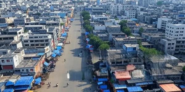
Hapur is a compact but economically important district in western Uttar Pradesh, with Hapur city as its administrative headquarters. It forms part of the National Capital Region and lies about 60 km east of New Delhi. The district was created on 28 September 2011 under the name Panchsheel Nagar and was renamed Hapur on 23 July 2012. Hapur is known for its grain and jaggery trade, stainless-steel and engineering industries, the textile and home-furnishing industry of Pilkhuwa, and the Ganga pilgrimage belt around Garhmukteshwar and Brijghat. The current district administration records 352 villages and 273 Gram Panchayats, while Uttar Pradesh government statistics place the district population at 13,38,311 based on 2011 figures.
Quick Overview of Hapur District

| Particular | Details |
| State | Uttar Pradesh |
| Division | Meerut Division |
| District Headquarters | Hapur |
| District Formation | 28 September 2011 as Panchsheel Nagar |
| Renamed Hapur District | 23 July 2012 |
| Area | About 660 sq. km |
| Population | 13,38,311 |
| Tehsils | 3 |
| Development Blocks | 4 |
| Gram Panchayats | 273 |
| Villages | 352 |
| Urban Local Bodies | 4 listed in the current district utility directory |
| Main Court | District & Sessions Court, Hapur |
| Main Railway Station | Hapur Junction |
| Railway Station Code | HPU |
| Railway Zone | Northern Railway |
| Railway Division | Moradabad Division |
| Main Hapur PIN Code | 245101 |
| Nearest Major Airport | Indira Gandhi International Airport, Delhi |
| Official District Website | Hapur district government portal |
The official Hapur website currently contains an area discrepancy. Its detailed About District and Demography pages use 660 sq. km, while the homepage At a Glance panel shows 1,116 sq. km. The Uttar Pradesh Economics and Statistics portal also records 660 sq. km, so this guide uses 660 sq. km as the more consistently supported figure. The current district Demography page does not publish a separate district literacy rate.
Location of Hapur District
Hapur lies in western Uttar Pradesh within the National Capital Region. Meerut district lies to the north, Bulandshahr to the south, Amroha to the east and Ghaziabad to the west. Its location between Delhi, Meerut and Moradabad gives the district strong road, rail and commercial connections. Hapur city is approximately 60 km east of New Delhi.
The district forms part of the fertile Indo-Gangetic Plain. Agriculture remains important, with wheat, sugarcane, paddy, maize, potatoes and pulses among the main crops. Industrial activity is concentrated around Hapur and Pilkhuwa, while the eastern side of the district reaches the Ganga at Garhmukteshwar and Brijghat.
Administration of Hapur District
Hapur city is the district administrative headquarters. The district has three tehsils:
- Hapur
- Dhaulana
- Garhmukteshwar
The district has four development blocks:
- Hapur
- Dhaulana
- Garhmukteshwar
- Simbhawali
The current Village & Panchayats page records 273 Gram Panchayats and 352 villages. Revenue administration is handled through the Collectorate, Sub-Divisional Magistrate offices, tehsils and village-level revenue staff.
Urban Local Bodies
The current district public-utility directory lists four urban local bodies:
- Nagar Palika Parishad Hapur
- Nagar Palika Parishad Pilkhuwa
- Nagar Palika Parishad Garhmukteshwar
- Nagar Panchayat Babugarh
The organisation-chart page separately highlights the three Nagar Palika Parishads, while Babugarh is listed as a Nagar Panchayat in the municipal directory.
Hapur District Court
Hapur has a separate district judgeship with District and Sessions Courts and subordinate civil and criminal courts. Official eCourts services can be used to check case status, hearing dates, cause lists, orders and CNR details. The judgeship also includes court jurisdiction for police stations across Hapur, Dhaulana, Pilkhuwa, Garhmukteshwar, Simbhawali and other parts of the district.
District Court Location
District & Sessions Court, Free Ganj Road, Hapur, Uttar Pradesh – 245101
The court is in central Hapur and is accessible from Hapur Junction, the main market areas and major city roads by autorickshaw, e-rickshaw, taxi or private vehicle.
Hapur Junction Railway Station
Hapur Junction is the principal railway station serving the district headquarters.
Railway Station Code: HPU
Indian Railways lists Hapur Junction under Northern Railway, Moradabad Division. It is classified as an NSG-4 station in the national station-category list. The junction provides rail connectivity towards Delhi and Ghaziabad on one side and Moradabad, Bareilly, Lucknow and other northern Indian destinations on the other, depending on the train.
Other useful railway stations in the district include Garhmukteshwar, Simbhaoli, Babugarh and Hafizpur. Travellers should choose the station according to their final destination rather than automatically travelling through Hapur city.
Hapur Railway Station Location
Hapur Junction is located within Hapur city and is well connected with the main market, Free Ganj, Delhi Road, Garh Road and other urban areas. Local autorickshaws, e-rickshaws and taxis are normally available outside the station.
Road Connectivity
Hapur has strong road connectivity because National Highway 9 passes through the district. The highway links Hapur with Delhi and Ghaziabad towards the west and Garhmukteshwar, Gajraula and Moradabad towards the east. Road links also connect Hapur with Meerut, Bulandshahr, Pilkhuwa, Dhaulana and Simbhaoli.
For pilgrims travelling to Garhmukteshwar and Brijghat, road transport is especially convenient. Traffic can become heavy on NH-9 during weekends, major festivals and the Kartik Purnima fair, so visitors should allow additional travel time during peak periods.
Nearest Airport to Hapur
Hapur does not have a commercial airport. The district How to Reach page identifies Indira Gandhi International Airport in Delhi as the nearest major airport. The same page displays a distance of about 58 km from Hapur, although other district tourism pages use older distance estimates. Actual road distance varies according to the airport terminal, route and traffic.
From Delhi airport, travellers can continue to Hapur by taxi or road transport, or travel towards Delhi or Ghaziabad railway stations and connect onward by train.
Hapur Pin Code
The main PIN code of Hapur city is 245101. India Post lists Hapur Head Office under PIN 245101. Different towns in the district use separate postal codes.
- Hapur – 245101
- Babugarh – 245201
- Garhmukteshwar – 245205
- Simbhaoli – 245207
- Bahadurgarh – 245208
- Pilkhuwa – 245304
Therefore, 245101 should not be used for every address in Hapur district. The exact PIN depends on the locality and serving post office.
Major Tourist Places in Hapur District
Garhmukteshwar
Garhmukteshwar is the district’s best-known pilgrimage town and is located on the Ganga. It has ancient religious associations and contains sites such as the Ganga Mandir and other temples. The town is connected by both road and rail and becomes especially busy during major bathing festivals.
Brijghat
Brijghat lies on the banks of the Ganga about 5 km from Garhmukteshwar and roughly 35 km from Hapur headquarters. It is known for its ghats, evening Ganga aarti and the large Kartik Purnima fair. Vedanti Temple, Ganga Mandir, Hanuman Mandir and other religious places are located around the ghat area.
Pilkhuwa
Pilkhuwa is known across India for handloom products, khadi, bed sheets, home furnishings and printed textiles. It is more of a craft and shopping destination than a conventional tourist attraction, and visitors interested in local textile production can combine it with a Hapur or Delhi-side journey.
Puth
Puth is a village on the Ganga associated in local tradition with the ancient name Pushpavati and stories from the Mahabharata period. The district’s Places of Interest page also mentions remains of an old temple and a mud fort associated with later historical periods.
Mukimpur
Mukimpur, near Pilkhuwa, is remembered locally for events connected with the uprising of 1857. District historical information links the village with Raja Gulab Singh and a fortification that once stood in the area.
FAQs About Hapur District
Q. Which railway station is best for Hapur city?
Hapur Junction, code HPU, is the main station for the district headquarters. It is the practical choice for the District Court, Collectorate, central markets and most Hapur-city destinations.
Q. Should I use Hapur Junction for Garhmukteshwar and Brijghat?
Not always. Garhmukteshwar has its own railway station, so a train stopping there can be more convenient for the pilgrimage area. For Brijghat, the final journey is by road from the Garhmukteshwar side.
Q. Is Brijghat suitable for a day trip from Delhi?
Yes. Brijghat lies on the Delhi-Moradabad NH-9 corridor and can be visited as a same-day trip. Weekend and festival traffic can significantly increase journey time, especially around Kartik Purnima.
Q. What is the difference between Hapur, Pilkhuwa and Garhmukteshwar for visitors?
Hapur is the administrative and commercial headquarters, Pilkhuwa is best known for textiles and home furnishings, while Garhmukteshwar and nearby Brijghat form the district’s main Ganga pilgrimage zone.
Q. Does Hapur have an airport?
No. Indira Gandhi International Airport in Delhi is the nearest major airport listed by the district administration. Road travel is normally the simplest onward option.