Kanyakumari, officially written as Kanniyakumari on the Tamil Nadu district portal, is the southernmost district of mainland India, with Nagercoil as its administrative headquarters. The district was created on 1 November 1956 when the Tamil-speaking taluks of Agasteeswaram, Thovalai, Kalkulam and Vilavancode were transferred from the former Travancore-Cochin State to Madras State during linguistic reorganisation.
Today Kanyakumari is known for its three-sea coastal setting, Western Ghats, high literacy, dense settlement, paddy fields, coconut and rubber cultivation, historic Travancore heritage and some of Tamil Nadu’s most recognisable tourist landmarks. Vivekananda Rock Memorial, the Thiruvalluvar Statue and sea bridge, Padmanabhapuram Palace, Suchindram Temple, Mathoor Aqueduct and Thirparappu Waterfalls are among its best-known attractions.
The current district portal gives an area of 1,672 sq. km and Census 2011 population of 18,70,374. Tamil Nadu’s official statistical handbook records a literacy rate of 91.75%, the highest among the state’s 2011 districts.
Quick Overview of Kanyakumari District
| Particular | Details |
| Official Government Spelling | Kanniyakumari |
| State | Tamil Nadu |
| District Headquarters | Nagercoil |
| District Formation | 1 November 1956 |
| Area | 1,672 sq. km |
| Population | 18,70,374 |
| Literacy Rate | 91.75% |
| Population Density | 1,119 per sq. km |
| Revenue Divisions | 2 |
| Revenue Taluks | 6 |
| Revenue Firkas | 18 |
| Revenue Villages | 188 |
| Development Blocks | 9 |
| Village Panchayats | 95 |
| Current Urban Structure | 1 Corporation, 5 Municipalities, 50 Town Panchayats |
| Main Court | District & Sessions Court, Nagercoil |
| Main Railway Station | Nagercoil Junction |
| Railway Station Code | NCJ |
| Railway Zone | Southern Railway |
| Railway Division | Thiruvananthapuram Division |
| Station Category | NSG-3 |
| Main Nagercoil PIN Code | 629001 |
| Nearest Major Airport | Thiruvananthapuram International Airport |
| Official District Website | kanniyakumari.nic.in |
The official portal contains a few stale or incorrectly copied pages. Its current Demography page is clearly unrelated to Kanyakumari and should not be used. The reliable 2026 Revenue Administration and Development pages give 2 divisions, 6 taluks, 188 revenue villages, 9 blocks and 95 Village Panchayats.
For urban administration, a newer district page records Nagercoil Corporation, 5 municipalities and 50 Town Panchayats, while an older homepage snapshot still gives 1 corporation, 3 municipalities and 55 Town Panchayats. The newer administrative record is used in this guide.
Location of Kanyakumari District
Kanyakumari occupies the extreme southern tip of the Indian peninsula. Kerala lies to the north and west, Tirunelveli district lies to the north-east, and the district opens to the Arabian Sea, Indian Ocean and Bay of Bengal along its southern and western coastline.
The district headquarters, Nagercoil, lies inland from Kanyakumari town and functions as the main administrative, educational, medical and commercial centre.
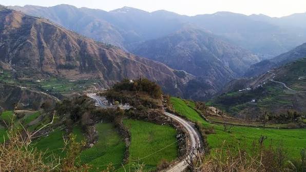
Although it is the smallest district in Tamil Nadu by area, it is one of the state’s most densely populated districts. The western and northern parts rise into the Western Ghats, while lower areas contain paddy fields, coconut groves, rubber plantations and a heavily settled coastal belt. The district portal records a coastline of about 71.5 km.
Administration of Kanyakumari District
Nagercoil is the district headquarters. Revenue administration consists of 2 revenue divisions, 6 taluks, 18 firkas and 188 revenue villages.
Nagercoil Revenue Division
- Agasteeswaram Taluk
- Thovalai Taluk
Padmanabhapuram Revenue Division
- Kalkulam Taluk
- Vilavancode Taluk
- Thiruvattar Taluk
- Killiyoor Taluk
The current revenue page records 43 villages in Agasteeswaram, 24 in Thovalai, 45 in Kalkulam, 28 in Vilavancode, 21 in Thiruvattar and 27 in Killiyoor, giving a total of 188 revenue villages.
Development Blocks
- Agasteeswaram
- Thovalai
- Rajakkamangalam
- Kurunthancode
- Thuckalay
- Thiruvattar
- Killiyoor
- Munchirai
- Melpuram
These nine blocks contain 95 Village Panchayats according to the current Development page.
Current Urban Local Bodies
Nagercoil is now a City Municipal Corporation. The current district administrative material records five municipalities:
- Kanyakumari Municipality
- Kollankodu Municipality
- Kuzhithurai Municipality
- Colachel Municipality
- Padmanabhapuram Municipality
It also records 50 Town Panchayats.
The latest district tourism pages themselves identify Kanyakumari as a municipality, while Tamil Nadu municipal records confirm Kollankodu’s upgrade from Town Panchayat to Municipality.
Kanyakumari District Court
The principal judicial establishment is the District and Sessions Court for Kanyakumari district at Nagercoil. The District Court Buildings also house the District Legal Services Authority and other civil and criminal judicial establishments.
District Court Location
District Court Buildings, Kanyakumari at Nagercoil, Tamil Nadu – 629001
Tamil Nadu State Legal Services Authority records list the District Legal Services Authority at the District Court Buildings, Kanyakumari at Nagercoil – 629001.
Separate judicial establishments operate elsewhere in the district, so litigants should confirm the exact court before travelling. Case status, cause lists, hearing dates, orders and CNR details can be checked through eCourts.
Nagercoil Junction Railway Station
Nagercoil Junction is the main railway station for the district headquarters.
Railway Station Code: NCJ
Southern Railway’s latest station list classifies Nagercoil Junction as an NSG-3 station under Thiruvananthapuram Division. It is an important junction for trains towards Thiruvananthapuram and Kerala, Tirunelveli, Madurai, Chennai and other parts of India.
Kanyakumari Railway Station
Station Code: CAPE
Kanyakumari railway station serves the tourist town at India’s southern tip. Southern Railway also lists Kanniyakumari as an NSG-3 station under Thiruvananthapuram Division.
For the Collectorate, District Court and central Nagercoil, NCJ is normally the more convenient station. For the Kanyakumari seafront, Vivekananda Rock Memorial, Thiruvalluvar Statue and Kumari Amman Temple, CAPE is more convenient.
Road Connectivity
Kanyakumari has strong road connectivity with Tirunelveli, Madurai, Thiruvananthapuram and the wider south Indian highway network.
NH-44, India’s major north-south highway, reaches Kanyakumari. Current NHAI records also show the Kerala-Tamil Nadu border to Kanyakumari stretch as NH-66, while NH-944 serves the Nagercoil-Kavalkinaru corridor.
Nagercoil has two important bus terminals: Vadassery for many mofussil services and Anna Bus Stand for local routes. The district’s compact size makes road travel practical for most tourist destinations.
Nearest Airport to Kanyakumari
Kanyakumari district does not have a commercial airport.
The current district How to Reach page identifies Thiruvananthapuram International Airport as the nearest major airport, about 90 km from Nagercoil and 110 km from Kanyakumari town.
Tuticorin Airport is another option for some domestic journeys and is listed by the district administration at approximately 105 km from Kanyakumari. For most travellers, Thiruvananthapuram provides the broader domestic and international flight network.
Kanyakumari Pin Code
The main PIN code of Nagercoil, the Collectorate and District Court is 629001. India Post lists Nagercoil Head Office, Nagercoil Town and Nagercoil Collectorate under 629001.
- Nagercoil – 629001
- Kottar – 629002
- Vetturnimadam – 629003
- Kuzhithurai – 629163
- Marthandam – 629165
- Thuckalay / Padmanabhapuram area – 629175
- Colachel – 629251
- Kanyakumari – 629702
- Suchindram – 629704
India Post directly confirms Nagercoil 629001, Kuzhithurai 629163, Thuckalay 629175, Kanyakumari 629702 and Suchindram 629704.
Therefore, 629001 should not be used for every address in the district. Kanyakumari tourist town itself uses 629702.
Major Tourist Places in Kanyakumari District
Kanyakumari Seafront, Vivekananda Rock and Thiruvalluvar Statue
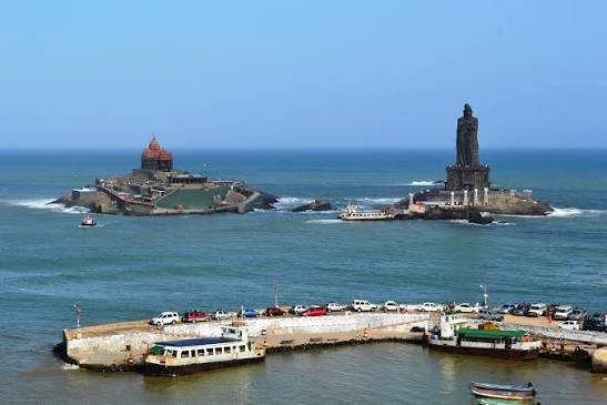
The Kanyakumari seafront is the district’s most famous visitor area, known for sunrise, sunset and the confluence of the Arabian Sea, Bay of Bengal and Indian Ocean.
Vivekananda Rock Memorial stands on an offshore rock roughly half a kilometre from the mainland. Beside it is the 133-foot Thiruvalluvar monument, comprising a 95-foot statue on a 38-foot pedestal. Ferry services connect the mainland with the offshore monuments.
Kanyakumari Glass Bridge
The glass bridge connecting Vivekananda Rock Memorial and the Thiruvalluvar Statue was inaugurated on 30 December 2024.
The district tourism page describes it as India’s first glass bridge built over the sea. It is 77 metres long and 10 metres wide, and tourists access it as part of the offshore monument visit.
Padmanabhapuram Palace
Padmanabhapuram Palace lies near Thuckalay and is one of the district’s most important historical monuments. It served as a royal residence of the Travancore rulers and is noted for its traditional timber architecture, carved interiors and royal chambers.
Although the palace is physically in Tamil Nadu, it is controlled by the Archaeology Department of the Government of Kerala. The district tourism page places it about 15 km from Nagercoil.
Suchindram Thanumalayan Temple
Suchindram is an important temple town between Nagercoil and Kanyakumari. The Thanumalayan Temple is associated with the Hindu trinity of Shiva, Vishnu and Brahma and is known for its sculpture, musical pillars and large Hanuman image. It lies conveniently on the Nagercoil-Kanyakumari travel corridor.
Mathoor Aqueduct
Mathoor Aqueduct is one of Kanyakumari’s most distinctive engineering landmarks. Built in 1966, the current district tourism page describes it as the tallest and longest trough bridge of its type in Asia, with a height of about 115 feet and a length of roughly one kilometre. It stands across the Parazhiyar near Aruvikkarai and is about 28 km from Nagercoil.
Thirparappu Waterfalls
Thirparappu Waterfalls lies about 42 km from Nagercoil on the Kodayar river system. The broad rocky cascade is one of the district’s most popular family and monsoon attractions.
The current tourism page lists visiting hours from 6:00 a.m. to 6:00 p.m., although water conditions can vary according to rain and upstream releases.
FAQs About Kanyakumari District
Q. Is Kanyakumari town the district headquarters?
No. Nagercoil is the administrative headquarters. Kanyakumari town is the famous coastal tourist and pilgrimage centre at the southern tip.
Q. Which railway station is best for the district headquarters?
Nagercoil Junction (NCJ) is the main station for Nagercoil, the Collectorate and District Court. For the Kanyakumari seafront, Kanyakumari station (CAPE) is more convenient.
Q. Does the district currently have 4 or 6 taluks?
The current Revenue Administration page lists six taluks: Agasteeswaram, Thovalai, Kalkulam, Vilavancode, Thiruvattar and Killiyoor. The original 1956 district was created from four taluks, which is why older historical descriptions mention four.
Q. Is Nagercoil a municipality or municipal corporation?
Nagercoil is now a City Municipal Corporation. Older pages that still describe it as a municipality are outdated.
Q. Which airport is nearest to Kanyakumari district?
Thiruvananthapuram International Airport is the nearest major airport, about 90 km from Nagercoil and 110 km from Kanyakumari town according to the district administration.
Q. Is 629001 the PIN code for Kanyakumari tourist town?
No. 629001 is the main Nagercoil PIN, while Kanyakumari town uses 629702.