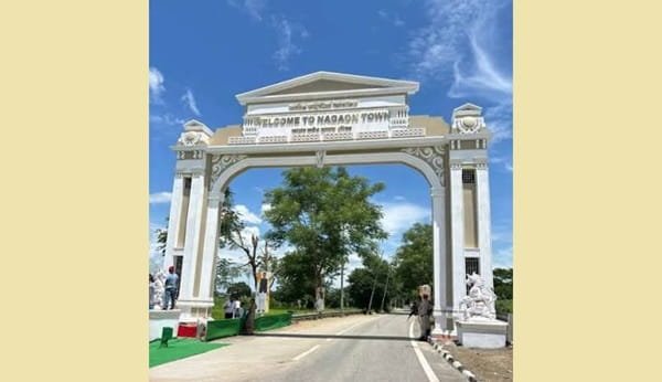
Nagaon is a centrally located district of Assam, with Nagaon town serving as its administrative headquarters. Historically known as Nowgong, Nagaon became a separate administrative district in 1832, while the present headquarters developed on the banks of the Kolong River from 1839. The district is known for the birthplace of Srimanta Sankardeva at Batadrawa, the Laokhowa-Burhachapori wildlife landscape, traditional Assamese jewellery, wetlands and its location on an important transport corridor between lower and upper Assam. The current district profile records an area of 2,287 sq. km, a population of 18,92,550 and literacy of about 71%.
Quick Overview of Nagaon District
| Particular | Details |
| State | Assam |
| Administrative Division | Central Assam Division |
| District Headquarters | Nagaon |
| District Formation | 1832 |
| Area | 2,287 sq. km |
| Population | 18,92,550 |
| Literacy Rate | About 71% |
| Sub-Divisions | 2 |
| Revenue Circles | 7 |
| Development Blocks | 13 |
| Revenue Villages | 960 |
| Gaon Panchayats | 169 |
| Urban Local Bodies | 4 Municipal Boards |
| Main Court | District and Sessions Court, Nagaon |
| Main Railway Station | Nagaon Railway Station |
| Railway Station Code | NGAN |
| Railway Zone | Northeast Frontier Railway |
| Railway Division | Lumding Division |
| Main Nagaon PIN Code | 782001 |
| Nearest Airport | Tezpur Airport |
| Official District Website | nagaon.assam.gov.in |
The current district portal lists two subdivisions, seven revenue circles, 13 development blocks, 960 revenue villages and 169 Panchayats. A 2026 district disaster plan confirms four urban local bodies.
Location of Nagaon District
Nagaon lies in central Assam on the southern bank of the Brahmaputra River. Its central position makes the district an important road and rail link between Guwahati and eastern Assam.
The district is bordered by the Brahmaputra and Sonitpur side to the north, Morigaon to the west, Golaghat and Karbi Anglong areas towards the east, and Hojai and Dima Hasao towards the south.
Important rivers include the Brahmaputra, Kolong and Kapili. The district contains fertile alluvial plains, wetlands and some forested and hilly areas.
Nagaon town is about 120 km from Guwahati, 75 km from Tezpur and 190 km from Jorhat by road.
Administration of Nagaon District
Nagaon town is the district headquarters.
The district has two subdivisions:
- Nagaon
- Kaliabor
There are seven Revenue Circles:
- Nagaon
- Raha
- Kampur
- Dhing
- Rupahi
- Samaguri
- Kaliabor
The district also has 13 development blocks responsible for rural development and Panchayat programmes.
Urban Local Bodies
The latest 2026 district disaster-management records identify four Municipal Boards:
- Nagaon Municipal Board
- Dhing Municipal Board
- Kampur Municipal Board
- Raha Municipal Board
These urban bodies manage sanitation, drainage, local roads, street lighting and other municipal services.
Nagaon District Court
The principal judicial establishment is the District and Sessions Court, Nagaon.
The Nagaon judiciary includes the District and Sessions Judge Complex, Chief Judicial Magistrate courts, Civil Judge courts, Motor Accident Claims Tribunal and other subordinate establishments. A separate judicial complex also functions at Kaliabor.
Citizens can use the official eCourts system for case status, CNR searches, hearing dates, cause lists and court orders.
District Court Location
The main judicial establishment is located at:
District and Sessions Judge Court Complex, Nagaon, Assam – 782001
Current Assam State Legal Services Authority records also place the District Legal Services Authority at the Office of the District & Sessions Judge, Nagaon.
The court complex is within Nagaon town and can be reached from the railway station, bus facilities and main commercial areas by local transport.
Nagaon Railway Station
Nagaon Railway Station is the principal railway station serving the district headquarters.
Railway Station Code: NGAN
Indian Railways lists Nagaon under Northeast Frontier Railway’s Lumding Division. The station is currently classified as an NSG-6 station.
Nagaon has direct rail links towards destinations including Guwahati and Silghat, while Chaparmukh Junction, around 30 km away, is an important nearby railway junction with additional train options.
The district headquarters also has Haibargaon Railway Station.
Nagaon Railway Station Location
Nagaon Railway Station is located around the MG Road/Panigaon area of Nagaon – 782001.
Local transport generally includes:
- Autorickshaws
- E-rickshaws
- Shared vehicles
- Taxis
- Local buses
Its location within Nagaon town makes it convenient for reaching government offices, markets and residential areas.
Road Connectivity
Nagaon has strong road connectivity with Guwahati, Kaziranga, Tezpur, Jorhat and other parts of Assam.
The modern NH 27 corridor passes through the Nagaon region and provides an important east-west road connection. NHAI records identify the Nagaon–Kaziranga and Nagaon-side stretches as part of NH 27.
Regular government and private buses operate between Nagaon and Guwahati, with the road journey typically covering around 120 km.
Nearest Airport to Nagaon
The nearest airport by road is Tezpur Airport at Salonibari, approximately 80 km from Nagaon.
For travellers needing a wider range of flights, Lokpriya Gopinath Bordoloi International Airport, Guwahati, around 130 km away, is generally the more practical major airport.
Nagaon Pin Code
The main PIN code of Nagaon town is 782001.
India Post officially lists:
Nagaon Head Post Office – 782001.
Other central Nagaon postal areas use codes such as 782002 and 782003. Villages and towns elsewhere in the district have separate PIN codes, so 782001 should not be used for every district address.
Major Tourist Places in Nagaon District
Batadrawa Than
Batadrawa Than, also called Bordowa Than, is the birthplace of Srimanta Sankardeva and one of Assam’s most important Vaishnavite pilgrimage centres. It is about 18 km northwest of Nagaon town according to the current tourism page.
Maha Mrityunjay Temple
Located at Ververi Gosaingaon, about 12 km from Nagaon, this Shiva temple is known for its distinctive 126-foot-tall Shivalinga structure.
Laokhowa-Burhachapori Wildlife Sanctuary
Laokhowa Wildlife Sanctuary covers around 70.13 sq. km and forms part of the wider Kaziranga Tiger Reserve landscape. It supports rhinos, elephants, tigers, wild buffaloes and rich birdlife.
Champawati Waterfall
Champawati Kunda at Chapanala is a popular nature and picnic destination surrounded by greenery and tea-growing areas. It is roughly an hour’s drive from Nagaon town.
FAQs About Nagaon District
Q. Which railway station should I choose if my train does not stop at Nagaon?
Chaparmukh Junction is usually the best alternative. It is around 30 km from Nagaon and handles more railway services than the smaller Nagaon station.
Q. Is Tezpur or Guwahati Airport better for a Nagaon trip?
Tezpur Airport is closer at about 80 km, but Guwahati Airport generally provides much wider flight connectivity. Travellers should compare flight availability with the extra road distance before booking.
Q. Does monsoon flooding affect travel in Nagaon?
It can. The Brahmaputra and several tributaries make parts of Nagaon vulnerable to flooding during heavy monsoon periods. Travellers heading towards rural, riverbank or wildlife areas should check current road and flood advisories during prolonged rain.
Q. When is Batadrawa Than especially crowded?
The annual Doul Mahotsav around Holi attracts very large numbers of devotees to Batadrawa. Visitors wanting a quieter visit should avoid peak festival days, while those interested in the religious celebration may prefer that period.